
We are very appreciative to have a guest post by Millán Millán, Executive Director, Institute CEAM-UMH in Spain. With my encouragement, he has accepted posting his excellent presentation this past summer
GUEST POST
European Union-United Nations International Strategy for Disaster Reduction
EU-UNISDR International Workshop, Brussels, 6-7 July 2010. Reducing Water-Related Risks in Europe
Climate Change Predictions, including Extreme Hydrometeorological Events.
by Dr. Millán Millán, Executive Director, Institute CEAM-UMH, Spain.
1. Introduction: A letter to Dr. Fritz Holzwarth, Director General for Water-Management, German Federal Ministry for the Environment, Nature Conservation and Nuclear Safety (12 July 2010).
Dear Dr. Holzwarth, enclosed please find a summary of our findings on the hydrological cycle in Southern Europe.
Data from European Projects from 1974 to the present have been re-analysed in the context of a perceived loss of summer storms around the Mediterranean (Millán et al. 2005a, b). In this respect, the first point to emphasise is that, geographically, Europe lies within two separate Hydrological Basins. That is, one part of Europe is in the North Atlantic Catchment Basin and the other part is in the Mediterranean Catchment Basin (Figure 1). The two are separated by the European Continental Divide, as illustrated in Figures 1 and 2. Our findings show that the hydrological cycle in these two parts operates differently. In the European regions north and west of the Continental Divide, the Atlantic Catchment Basin gets most of its water from “Classic weather systems”, i.e., travelling depressions and their associated fronts coming from the Atlantic. Land-use changes within this divide will mainly affect the capacity of the surface to retain water, and, thus, they can affect the frequency and intensity of floods.
In contrast, on the Mediterranean side of the European Divide, the Atlantic precipitation component is weak or non-existent (e.g., Greece, Turkey), and the main precipitation comes from summer storms and Mediterranean Cyclogenesis. The latter events can be triggered either by orographic lift and/or by the advection of an upper perturbation (i.e., cold trough aloft) moving south from more northerly latitudes. This has caused some meteorologists to classify Mediterranean Cyclogenesis events as resulting from “Atlantic fronts” when, in reality, the water vapour involved in the precipitation has mainly originated within the Mediterranean Basin (Pastor et al. 2001). In other words, most of the water that precipitates in summer-storm and Mediterranean-Cyclogenesis events in the Mediterranean Basin has been evaporated from, and is thus recirculated within, the Mediterranean Catchment itself. Having identified this, our findings further suggest that land use is a key component in this process as it governs both how much, and how, the water is recirculated in this basin.
Our study shows that summer storms around the Western Mediterranean Basin are directly affected by land-use changes, and when these storms are lost, a chain of events is triggered which leads to an accumulation of water vapour over the Mediterranean Sea and an increase in summer floods in Central Europe. Moreover, the focuses for the most intense summer precipitation (and flood) events, involving Vb tracks, seem to occur right along the European Continental Divide (Figures 2, and 3), and could also result from the convergence of Atlantic and Mediterranean moist airmasses.
Another problem is the common assumption, with respect to the hydrological cycle, that the water resource is universally provided by precipitation from the large weather systems. As this is not true in most parts of the world, the notion that the water resource is there and all that is required is to manage it properly is perhaps the most widely extended fallacy regarding the water cycle (in Europe). In the northern hemisphere (Figure 1), this assumption holds only in the Atlantic and Pacific Divides north of » 35º North Latitude. Moreover, it can only be truly asserted for the western (oceanic) sides of the continents, i.e., the European-Atlantic and American-Pacific sides of the continents.
For any other Water Catchment Basin in the world, other processes must be considered. For example, the available precipitation in the Central North American Basin, which is lodged between the Pacific and North Atlantic Divides, is strongly modulated by conditions in the Gulf of Mexico, i.e., by processes and conditions at the Regional to Subcontinental scales. In tropical forest areas (i.e., rainforests), after a massive inflow of water vapour at the beginning of the wet season, the water is basically recirculated between the soil-forest and the atmosphere, producing a daily afternoon-evening shower. Thus, rainforest means exactly that: take the forest away and the rain goes along with it, allowing the area to become a desert and/or prone to major floods. The rainforest is probably the ultimate case in which surface properties govern the precipitation during the wet period.
A synthesis of our findings on the hydrological cycle in Southern Europe and its possible consequences for the rest of the continent is presented in Figure 4 (EC 2007). This is discussed in more detail in a report prepared for Peter Gammeltoft (DG ENV) from work done within the EC CIRCE Integrated Project, i.e., the Gammeltoft-CIRCE_RACCM report. Some of the details, and the implications for Climate Models, were discussed at the EC_UNISDR Workshop, Brussels 6-7 July 2010, and the extended Abstract is included below.
2. Extended Abstract EU-UNISDR International Workshop, Brussels, 6-7 July 2010.
“It is very likely that hot extremes, heat waves and heavy precipitation events will continue to become more frequent”. This is a conclusion common to all IPCC Assessment Reports. However, “although the ability of Atmosphere-Ocean General Circulation Models (AOGCMs) to simulate extreme events, especially hot and cold spells, has improved, the frequency and amount of precipitation falling in intense events are underestimated” (IPCC 2007). It is also likely that the latter situation will continue for a long time, that is, unless the meteorological basis of current Climate Models manages to become able to simulate specific local-to-regional processes, such as land-atmospheric-oceanic feedbacks or the folding of boundary layers in complex coastal terrains in the sub-tropical latitudes.
Nevertheless, some of the observed anomalies and results of these processes were indeed addressed both in the Fourth Assessment Report AR4 (IPCC 2007) and in the earlier Third Assessment Report TAR (IPCC 2001), as information resulting from EC research filtered into the system. In this context, the present work reviews some of the processes that should be considered to improve AOGCMs, with reference to specific quotes and comments in the AR4.
Information gathered during various European Commission (EC) research projects in the areas of Atmospheric Chemistry and Desertification, i.e., some 37 projects from 1974 to 1994, had alerted of a loss of summer storms around the Western Mediterranean Basin. This issue was addressed in 1995 by re-analysing the meso-meteorological information obtained in nine of the EC projects and disaggregating the precipitation components for one of the experimental areas used in these projects (Valencia, eastern Spain). The results of the analysis (Millán et al. 2005a, b), shown in Figure 5, identify three sources of rain in this region, viz: Atlantic Fronts which contribute <20% of total precipitation; Summer Storms, 11% to 16% of total precipitation; and Mediterranean Cyclogenesis, >65% of total precipitation. These precipitation components come from different weather patterns. Moreover, the correlation of the Atlantic fronts with the NAO (North Atlantic Oscillation) is negative while the correlation with Mediterranean Cyclogenesis is positive (Millán et al 2005b).
This situation regarding the origin of the precipitation components appears to be the norm, rather than the exception, in the entire Mediterranean Basin and probably in other subtropical areas of the world, which include a very important part of the Global Climate System. Furthermore, in the Mediterranean Basin the contribution from Atlantic depressions has been decreasing for the last 50 years, summer storms over the mountains surrounding the Mediterranean Sea have nearly disappeared in the last 30 years, while extreme precipitation events associated with Mediterranean Cyclogenesis appear to be increasing rapidly and becoming more torrential in nature. It is important to emphasise this because current Coupled AOGC Models are unable to distinguish between precipitation components in these latitudes. Finally, our analysis of EC project results shows that both summer storms and intense precipitation events due to Mediterranean Cyclogenesis appear to be governed by land-use-atmospheric-oceanic feedbacks.
For example, summer storms form (or used to form) in the afternoon over the mountains surrounding the western Mediterranean basin at 60 to 80(+) km from the sea, as the final stage in a coastal wind system that develops during the daytime in summer and combines the sea breeze and the up-slope winds, henceforth called the combined breeze. The specific characteristics of this wind system have been documented in several European Commission projects (Millan et al. 1997; 2000, 2002) and derive from the nature of the Western Mediterranean Basin (WMB). That is, a large and deep sea, totally surrounded by high mountains in the subtropical latitudes. The following features make this wind system different from a “classic seabreeze” (Munn 1966, Stull 1988):
(1) Upslope wind cells develop early in the morning, i.e., right after sunrise, over the east-and-south facing slopes (Millán et al. 1991,; 1992).
(2) The seabreeze develops at mid morning and, during July-August, its average duration and the wind travelled distance at the coast are, respectively, 14 hours and 160 km (Millán et al. 2000).
(3) The seabreeze progresses inland in a stepwise manner, by incorporating one after another the up-slope wind cells formed earlier that day (Figure 6). This is in contrast to the smoother penetration in a classic seabreeze over flat coastal areas.
(4) After advancing each step, the leading edge (or front) of the combined breeze can remain stationary over that position for » 1/2 to 1 hour, or more. This process was first observed after tracking the evolution of the small cumulus clouds forming at the leading edge of the breeze (Millán et al. 1992)
(5) It can take from » 4 to 6 (+) hours for the front of the combined breeze to reach all the way from the coast to the top of the mountains 60 to 100 km inland.
(6) Once the front reaches the mountain tops, it tends to become locked onto that position, i.e., this becomes the last step, and it remains there for 4 to 6 h, until the end of the breeze period (Salvador et al. 1997).
At the leading edge of a “classic” seabreeze a curtain of air is uplifted from the surface and injected into the return flows aloft, while the seabreeze front progresses smoothly inland (Munn 1966). In the combined breeze, however, the front advances to a certain position and remains there for a period of time, until the breeze front moves (jumps) to the next position, and so on. Because the positions of the front are conditioned by the orography, and the injection over each of those points resembles the mechanism creating “chimney clouds” (Huschke 1986), the term convective-orographic “chimney” will be used henceforth to describe the situation described. Thus, during the stationary period, a considerable part of the airmass reaching the front from the surface becomes injected directly into the return flows aloft, and the length of the layers formed at each chimney (see below) could be comparable to the distance that separates the base of that chimney from the previous one.
Another noteworthy feature is that the altitude of the injections increases at each new position of the leading edge, i.e., at each newly formed chimney, both because the airmass gains potential temperature as it follows a longer path along the heated surface, and because the base of consecutive chimneys occurs at ever increasing heights up the mountain slopes. Finally, at each step, the return flows move seaward and sink (subside) along their way. The amount of sinking that the return flows sustain is also comparable to the altitude of the base of the chimney in which they were injected. Finally, the sinking also tends to increase the stability of the returning airmass and favours the formation of layers over the coastal areas and the sea (Figure 7, Millán et al. 2000). All of these mechanisms form part of a “closed” vertical circulation loop that grows during the day, reaches its maximum development in the afternoon, and ceases by evening, only to begin anew the following day.
The number of steps that the combined breeze takes to reach the mountain ridges inland and, thus, the number of chimneys and layers formed during its development depend on the lay of the slopes around the Western Mediterranean basin (Figures 7, 8 and 9). During this process, storms can develop whenever the Convective Condensation Level (CCL) of the incoming air mass is reached within the leading edge of the combined breeze, i.e., at its current chimney position. This can trigger deeper (moist) convection and the development of a storm. Finally, if storms do develop, the air mass becomes mixed all the way up to the tropopause, and the closed-loop coastal wind system becomes “OPEN”. That is, the described wind system ends up behaving like a small monsoon.
The formation of storms, however, requires the addition of water (e.g., evaporated from the surface, wetlands, irrigated crops, etc.) to the airmass coming inland from the sea. This is required to counterbalance the heating that the air mass sustains as it moves inland along the heated surface, and bring the CCL of the incoming airmass below its height of injection into the return flows aloft. Otherwise, heating prevails and the CCL of the incoming airmass will keep on rising, the combined breeze will keep progressing inland, and a “first critical threshold” (or tipping point) in this wind system will be crossed when the CCL becomes higher than the height of the injections over the mountain tops. Under these conditions the coastal circulations will stay “CLOSED”. That is, storms will not develop, and the return flows aloft will continue moving seaward during the entire day, forming layers that contain the non-precipitated water vapour and the pollutants carried by the combined breeze, and piling them up to 4500(+) m over the Western Mediterranean Basin (Figure 8). Moreover, because summer precipitation will decrease if storms do not develop, the conditions that maintain the combined breeze as a “closed” wind system (viz. insufficient evaporation along its surface path) can be considered part of a first feedback loop that tips the local climate towards increased drought inland (Figure 4).
To simulate these processes, e.g., the development of the sea breeze, mesoscale meteorological models require the use of grids smaller than 10 km x 10 km (Salvador et al. 1999). But even when using smaller grids (i.e., 5 km x 5 km) and vertical resolutions at the limit of numerical instability (e.g., 36 m), current models are not able to reproduce all the structures documented experimentally over the Western Mediterranean (Figure 9). This can be considered relevant as AR4 Section 8.2.2.2 Horizontal and Vertical Resolution states that “Changes around continental margins are very important for regional climate change”.
Moreover, if these closed-loop conditions develop in other coastal areas of the Western Mediterranean, they can become self-organised during the day to originate a meso-a scale circulation extending to the whole Basin. In this case, the chimneys at the leading edges of the combined breezes will join together to form well-defined convergence lines along the mountains surrounding the basin, i.e., some 60 to 100 km inland from the coasts (Figure 10). As a result, a generalised and intense compensatory subsidence will also develop over the coastal areas and the sea which will keep the surface layer confined below ≈ 200 m (Figure 11). This vertical confinement has been observed to extend all the way from the coast to each of the orographic chimneys formed along the path of the combined breeze and, eventually, to the last chimney that forms in the late afternoon as far as 80 to 100 km inland. These boundary layer depth values, and typical rates of evaporation over irrigated areas and mountain maquia, were used to estimate the critical thresholds illustrated in Figure 9.
In the Western Mediterranean Basin, the “closed loop” conditions have been documented to last from 3 to 9 consecutive days, and recur several times a month, i.e., for a total of 12 to 24 (+) days per month, from late spring to late summer (May-September). During these periods the Western Mediterranean Basin behaves like a large cauldron that boils from the edges towards the centre. In this cauldron, each day, the coastal circulations recirculate (vertically) from » 1/4 to 1/2 of the depth of the layers accumulated over the sea on the previous days.
The self-organisation of the local circulations from the meso-g scale (to » 20 km), through the meso-b scale (to » 200 km), to a full-fledged meso-a scale (to » 2000 km) circulation during the day can be considered a good example of atmospheric properties and processes spilling up and down the meteorological scales, typical of sub-tropical latitudes. It also means that when storms do not develop, at each step in the penetration of the combined breeze, part of the air travelling along the surface becomes injected into the return flows and folds over the top of the return layers formed in the previous step (Figures 7 and 8). Therefore, the temperature and humidity profiles observed over the coastal areas and the sea are the result of the systematic folding of the surface boundary layers over the sea on several consecutive days, together with other processes, e.g., the sinking and re-stacking of the layers according to their potential temperatures, too complex to discuss here.
The development of large meso-scale circulations around large-enclosed (Mediterranean) or semi-enclosed (e.g., Sea of Japan) seas could underscore two other aspects mentioned in AR4 when referring to Continental edge effects and lapse rates (8.6.3.1 Water Vapour and Lapse Rate). This document states that “In the planetary boundary layer, humidity is controlled by strong coupling with the surface, and a broad-scale quasi-unchanged RH response is uncontroversial”. The uncontroversial part of this statement could be just another fallacy regarding the Atmosphere-Land connection in Climate Change Models (Figure 13). That is, for any region outside flat terrains in mid latitudes. The statement is false because when the edges of the continents wrap around a large interior sea like the Mediterranean, or a large semi-enclosed sea like the Sea of Japan, Continental Edge effects blend together to create their own large meso-meteorological circulation and dominate the weather patterns in these regions for months.
Finally, the “Continental Edge Effect” becomes particularly important if the continental edges are backed by complex coastal terrains, that is, coasts backed by high mountains up to 80(+) km from the sea. The reason for this, as related above, is that the combined breezes make the coastal boundary layers fold over themselves, creating a multitude of “residual boundary layers” piled-up several km high over the enclosed seas. The EC’s MECAPIP and RECAPMA (MEso-meteorological Cycles of Air Pollution in the Iberian Peninsula – MECAPIP, 1988-1991, REgional Cycles of Air Pollution over the West-Central Mediterranean Area – RECAPMA 1990-1992) projects documented as many as 7 layers piled-up over the Mediterranean to 4500 m (Millán et al. 1992), which could explain the observed temperature lapse rates (Figures 7 and 8) and the water vapour profiles observed over some coastal areas, and over large interior seas in sub-tropical latitudes.
The observed profiles include temperature increases from 13K to 19K in the return flows (Figure 8) and a higher water content (i.e., perturbed RH) in the upper layers than in the layers directly above the sea. This is the result of the evaporation added during their flow path over land (albeit not enough to trigger storms, as mentioned above). The observed temperature and moisture profiles can thus be considered “anomalous” with respect to current advection-dominated model simulations, which assume that the water vapour is evaporated directly from the surface (or comes from upstream). And because the models are unable to simulate the systematic folding of the surface boundary layer over itself for several consecutive days, they cannot simulate the resulting accumulation of atmospheric properties (i.e., temperature, pollutants and water vapour) in layers over the coastal areas and the (large interior) sea.
Current numerical simulation models, even when using 2km x 2km grids, do not capture all the details of the observed processes; e.g., they cannot reproduce either the vertical recirculations or the layering over the sea. Nevertheless, the outcome of these processes, i.e., the development of an accumulation mode for water vapour (and pollutants) over the sea, has been validated with water column data from NASA-MODIS ever since the year 2000 (Figure 13). MODIS data (Gao and Kaufman 2003) show that there is an intense and prolonged accumulation mode over the Western Basin and the Black Sea in summer, and two weaker accumulation modes over the Eastern Basin in spring and autumn.
These vertical recirculation-accumulation modes make the weather and climate in the Mediterranean Basin, and other semi-enclosed seas in the subtropical latitudes, very different from in the mid latitudes. Thus, in contrast with regions dominated by advection, in the Western Mediterranean Basin, water vapour and pollutants can accumulate in layers piled-up to 4500(+) m over the sea, for extended periods during the summer. And, without requiring the high evaporation rates of more tropical latitudes, the above-described mechanisms are able, in just a few days, to generate a very large, deep and polluted air mass that increases both in moisture content and in potential instability with each passing day.
The accumulation periods end (i.e., every few days) when the moist and polluted air masses are vented out of the area by an upper atmospheric perturbation. Under certain conditions the accumulated water vapour can contribute to an increase in intense precipitation events and summer floods in Central and Eastern Europe. Finally, during the vertical recirculation-accumulation periods, the greenhouse effect of the water vapour (Figure 14), photo-oxidants (ozone) and aerosols accumulated in layers over the sea enhances sea surface temperature heating during summer. This propitiates a second feedback loop where Mediterranean Cyclogenesis fed by a warm(er) sea (Pastor et al. 2001) contributes to an increase in torrential rains and floods in Mediterranean coastal areas from autumn to spring (i.e., effects delayed by a few months with respect to the closing of the first loop).
In this second feedback loop another “critical threshold” may then be crossed if torrential rains, during intense Mediterranean Cyclogenesis events, trigger flash floods and/or mud flows over mountain slopes already affected by the first feedback loop, i.e., drier and vegetation-deprived. This can increase erosion and/or produce massive soil losses which, in turn, can further reinforce the first feedback loop and help propagate its effects (desertification, drought), to other parts of the Mediterranean basin. Available evidence indicates not only that these processes and feedbacks have been operating in the Mediterranean for a long time, but also that fundamental changes and long-term perturbations to the European water-cycle (extended droughts and intense floods) are taking place right now.
This analysis further suggests that: up to 75% (or more) of the precipitation in southern Europe, i.e., from Summer storms and Mediterranean Cyclogenesis, originates from water that first evaporates and then precipitates, i.e., it is recirculated, within the major Mediterranean drainage basin (i.e., all the areas south and east of the European Continental Divide including the Mediterranean and Black Seas). Moreover, on the Mediterranean side of this Divide, rain of Atlantic origin contributes less than » 20% of the total (probably even less than that in Greece), whereas on the Atlantic side of the European Divide, » 80% to 90% or more of the precipitation is from water evaporated over the Atlantic Ocean.
Finally, land-use appears to play a key role in the loss of summer storms, the shift to more frequent vertical recirculation periods, and the amount of water recirculated within the Mediterranean basin. These findings and the questions they raise are critical for the Mediterranean side of the European Divide:
(a) Drought and torrential rains in areas around enclosed seas in the subtropical latitudes (e.g. Mediterranean, Sea of Japan, South China Sea?) are the result of the same concatenated meteorological processes involving atmosphere-land-oceanic feedbacks.
(b) The same processes can also lead to intense precipitation events and summer floods in other parts of Europe (i.e., points along the European Continental Divide, or within the Mediterranean Catchment side of the Divide).
(c) Moreover, through the intensification of the Atlantic-Mediterranean Salinity Valve, the North Atlantic Oscillation could be perturbed and affect precipitation regimes on the Atlantic side of the European Continental Divide.
(d) That is, the local-to-regional perturbations initiated by land-use changes at the local level can propagate their effects to the Global Climate System.
(e) The basic atmosphere-land-ocean exchange governing these processes is not (and probably cannot be) included in current Atmosphere-Ocean General Circulation Models (AOGCMs).
(f) Thus, the feedback processes in the hydrological cycle, which govern the partitioning and recirculating of water vapour and precipitation, as well as the development of extreme hydro-meteorological events, cannot currently be simulated in the AOGC Models used to assess extreme events in sub-tropical latitudes.
This situation now presents the research community with very important challenges to improve current Atmosphere-Land-Oceanic parametrisations in Atmosphere-Ocean General Circulation Models. It confirms that hasty decisions on the future of the water cycle could be wrong and have catastrophic consequences not only for Southern Europe, but also for the rest of Europe.
REFERENCES
European Commission, 2007: International Workshop on Climate Change Impacts on the Water Cycle, Resources and Quality. Report EUR 22422. Luxembourg: Office for Official Publications of the European Communities, 149. ISBN 92-79-03314-X
Gao B.-C., Y. J. Kaufman, 2003: Water vapour retrievals using Moderate Resolution Imaging Spectroradiometer (MODIS) near-infrared channels, J. Geophys. Res., 108, NO D13, ACH 4-1, 4-10.
Huschke, R.E. (Ed.), 1986: Glossary of Meteorology. American Meteorological Society, Boston, Mass., 638 pp.
IPCC, (TAR) 2001: Climate Change 2001: Synthesis Report. A contribution of Working Groups I, II, and III to the Third Assessment Report of the Intergovernmental Panel on Climate Change [Watson, R.T. and the Core Writing Team (eds.)]. Cambridge University Press, Cambridge, United Kindom, and New York, NY, USA, 398 pp.
IPCC, (AR4) 2007: Climate Change 2007: The Physical Science Basis. Contribution of Working Group I to the Fourth Assessment Report of the Intergovernmental Panel on Climate Change [Solomon, S., D. Qin, M. Manning, Z. Chen, M. Marquis. K.B.Averyt, M. Tignor and H.L.Miller (eds.)]. Cambridge University Press, Cambridge, United Kindom, and New York, NY, USA, 996 pp.
Kemp, M., 2005: (H. J. Schellnhuber’s map of global “tipping points” in climate change), Inventing an icon, Nature, 437, 1238.
King, M. D., W. P. Menzel, Y. J. Kaufman, D. Tanré, B.-C. Gao, S. Platnick, S. A. Ackerman, L. A. Remer, R. Pincus, and P. A. Hubanks, 2003: Cloud and Aerosol Properties, Precipitable Water, and Profiles of Temperature and Water Vapor from MODIS, IEEE Transactions on Geoscience and Remote Sensing, 41, 442-458.
Millán M.M., B. Artíñano, L. Alonso, M. Navazo and M. Castro, 1991: The effect of meso-scale flows on the regional and long-range atmospheric transport in the western Mediterranean area. Atmos. Environ. 25A, 949-963.
Millán, M.M., B. Artíñano, L. Alonso, M. Castro, R. Fernandez-Patier and J. Goberna, 1992: Meso-meteorological Cycles of Air Pollution in the Iberian Peninsula, (MECAPIP), Contract EV4V-0097-E, Air Pollution Research Report 44, (EUR Nº 14834) CEC-DG XII/E-1, Rue de la Loi, 200, B-1040, Brussels, 219 pp.
Millán, M.M., R. Salvador, E. Mantilla, & G. Kallos, 1997: Photo-oxidant dynamics in the Western Mediterranean in Summer: Results from European Research Projects. J. Geophys. Res., 102, D7, 8811-8823.
Millán, M.M., E. Mantilla, R. Salvador, A. Carratalá, M. J. Sanz, L. Alonso, G. Gangoiti, & M. Navazo, 2000: Ozone cycles in the Western Mediterranean Basin: Interpretation of monitoring data in complex coastal terrain. J. Appl. Meteor., 39, 487-508.
Millán, M. M., Mª. J. Sanz, R. Salvador, & E. Mantilla, 2002: Atmospheric dynamics and ozone cycles related to nitrogen deposition in the western Mediterranean, Environmental Pollution, 118(2), 167-186.
Millán, M.M., Mª. J. Estrela, Mª. J. Sanz, E. Mantilla, & others, 2005a: Climatic Feedbacks and Desertification: The Mediterranean model. J. Climate, 18, 684-701.
Millán, M.M., Mª. J. Estrela, J. Miró, 2005b: Rainfall Components Variability and Spatial Distribution in a Mediterranean Area (Valencia Region). J. Climate, 18, 2682-2705.
Munn, R.E., 1966: Descriptive Micrometeorology, Academic Press, New York, 245 pp.
Pastor, F., Mª. J. Estrela, D. Peñarrocha, M.M. Millán, 2001: Torrential Rains on the Spanish Mediterranean Coast: Modelling the Effects of the Sea Surface Temperature. J. Appl. Meteor., 40, 1180-1195.
Pielke, R. A., W. R. Cotton, R. L. Walko, C. J. Tremback, W. A. Lyons, L. D. Grasso, M. E. Nicholls, M. D. Moran, D. A. Wesley, T. L. Lee, J. H. Copeland, 1992: A comprehensive Meteorological Modelling System-RAMS. Meteorol. Atmos. Phys., 49, 69-91.
Portelli R.V., Kerman B.R., Mickle R.E., Trivett N.B., Hoff R.M., Millán M.M., Fellin P., Anlauf K.S., Wiebe H.A., Misra P.K., Bell R. and Melo O. (1982) The Nanticoke shoreline diffusion experiment, June 1978. Atmos. Environ. 16, 413-466.
Salvador, R., J. Calbó, and M.M. Millán, 1999: Horizontal grid size selection and its influence on mesoscale model simulations. J. Appl. Meteor., 38, 1311-1329.
Stull, R. B., 1988: An Introduction to Boundary Layer Meteorology, Kluwer Academic Publishers, Dordrecht, The Netherlands, ISBN 90-277-2769-4, 666 pp.
Ulbrich, U., T. A. Brücher, A. H. Fink, G. C. Leckebusch, A. Krüger, G. Pinto, 2003: The central European floods of August 2002: Part 2 – Synoptic causes and considerations with respect to climatic change. Weather, 58, 371-377.

Figure 1. Drainage Basins of the World (UN). When referring to the Mediterranean Basin, most Europeans think of the coasts of Spain, France, Italy, Greece and (maybe) Israel. They normally consider the Black Sea as a separate (Russian ?) entity; and, if pushed a bit, they will, of course, reconsider and include the coasts of North Africa. This situation tends to confuse the issue when talking about the Mediterranean Basin in Central-Northern Europe. The real and “whole” Mediterranean Catchment Basin, however, extends to the sources of the Nile River, and includes the Black Sea Catchment Basin as well as other parts of Europe that are not usually considered Mediterranean (e.g., Austria, Hungary). Yet, all these are geographically Mediterranean, and, like it or not, they are all under the climatic and hydrological influence of the Mediterranean Sea. Grey areas are endorheic basins that do not drain to the ocean.

Figure 2. Colour-coded altitude map of Europe. The dark-blue line marks, in higher resolution than Figure 1, the European Continental-Water Divide. It follows the high ground and the peaks of the major mountain ranges. To the right of the divide all waters drain into the Mediterranean, and to the left they drain to the Atlantic. Depending on the meteorological conditions, e.g., advection across the divide, Föhn type effects tend to keep most of the water vapour carried by the airmasses on the upwind side of the divide. Thus, these mechanisms limit the amount of water vapour transported from one side of the divide to the other. In other conditions, the divide favours surface convergence of Atlantic and Mediterranean airmasses and becomes the focus for intense precipitation and runoff to either side of the divide (see Figure 3). However, the following questions remain: how much of the runoff on each side of the divide proceeds from water vapour converging from the same side?, what conditions favour the net transfer of water from one side of the divide to the other?, and where along the divide, and how much?

Figure 3. Left. MODIS (Gao and Kaufman 2003; King et al. 2003) water vapour column Day + Night product averaged for August 2002. It shows the monthly average of the water vapour column accumulated over the Western Mediterranean in August 2002 . The monthly average is approximately equal to the water vapour column accumulated after a 3-4 day vertical recirculation period, and is available for advection to other regions. The graph at right from Ulbrich et al. (2003) shows the back trajectories (type Vb) that fed torrential rains in Germany and the Czech Republic on 11-13 August, 2002. Looking at Figures 2 and 3, it can be seen that this intense precipitation event took place over a section of the European Continental Divide located between Germany and the Czech Republic. These figures illustrate the evident interconnection between hydrological processes from the local to the regional scale in Europe. That is, a local loss of summer storms around the Western Mediterranean, caused by land use changes, leads to a local-to-regional vertical recirculation mode over the Western Mediterranean, and this accumulates water vapour that can participate in major precipitation events, and floods, in other parts of Europe.

Figure 4. Feedback loops between land-use perturbations in the Western Mediterranean basin and the climatic-hydrological system from the local through the regional to the global scales (EC 2007). The first-local-loop involves the combined seabreezes and upslope winds that end with storms developing in the afternoon over the mountain ranges surrounding the basin. A first critical threshold occurs when the Cloud Condensation Level exceeds the height of the mountains and the loop closes. The closed wind system has a diurnal cycle, a scale of the order of 100 km to 300 km for the surface inflow and return flows aloft, and it can be repeated for periods of 3 to 7+ consecutive days in summer. The second-regional-loop results from the radiative (greenhouse) effect of the water vapour and pollutants accumulated over the sea during these periods, which affects the evolution of the Sea Surface Temperature in the Western Basin during summer. This warm(er) water then feeds torrential rains in autumn and, more recently, also in winter and spring. Another critical threshold is associated with the triggering of mud flows, and massive soil losses, over the vegetation-deprived mountain slopes. Finally, the Atlantic-global loop has two components that can affect the North Atlantic Oscillation (NAO). The oceanic component derives from losing the moisture accumulated over the Western Mediterranean to feed summer floods in Central-Eastern Europe; it favours the output of saltier water to the Atlantic (Kemp 2005). The other path involves perturbations to the extra-tropical depressions and hurricanes in the Gulf of Mexico caused by changing the characteristics of the Saharan dust transported across the Atlantic. In this figure the path of the water vapour is marked by dark blue arrows, the directly related effects by black arrows, and the indirect effects by other colours. Critical thresholds are squared in red and indicate when the system tips to a different state.

Figure 5. Spatial and temporal disaggregation of the precipitation components for the Valencia Region and neighbouring areas in Spain. 50-year daily precipitation series from 497 sites were used. A key aspect is that the water from components B and C, amounting to more than 75% of the total precipitation in this area, is evaporated from the Mediterranean sea. This suggests that the water in these two components may simply be recirculated within the basin.

Figure 6. Left side. Detail of the ozone and water vapour across 350 km of the Iberian Peninsula (from Castellón to Guadalajara) measured from an instrumented aircraft during the MECAPIP project at 1449-1559 UTC on 20 July 1989 (Millán et al 1992). The sawtooth trajectory is marked by dots. If storms do not develop, pollutants (ozone) and water vapour follow the return flows of the breezes aloft to form layers over the sea. Three layers can be observed at this time, and an example of the resulting structure over the sea is shown in Figure 8. Water vapour can thus be used as a tracer of opportunity to characterise the dynamics of the airmasses recirculated by the coastal wind systems in the Western Mediterranean Basin. The green arrow shows how a vertical-looking satellite, i.e., the NASA MODIS-Terra (King et al. 2003), would see a large column value when looking down the orographic chimneys developing at the leading edge of the combined breezes (Figure 12). Right side. RAMS (Pielke et al. 1992) simulation of the wind over the last 180 km of the flight plane (marked by MODEL ® in the graph), at 1600 UTC on the same day (2 km x 2 km grid size); to emphasise the structure, the vertical component of the wind has been multiplied by ten. It shows the convective/orographic chimney at the end of the combined breeze, » 90 (+) km inland at this time. The red lines mark the approximate vertical boundaries of the flight path, making it obvious (now) that the flight did not reach high enough to fully capture the depth of the vertical injections! The model does reproduce the main features of the flows but does not capture the fine details (i.e., all the layers formed in the return flows).

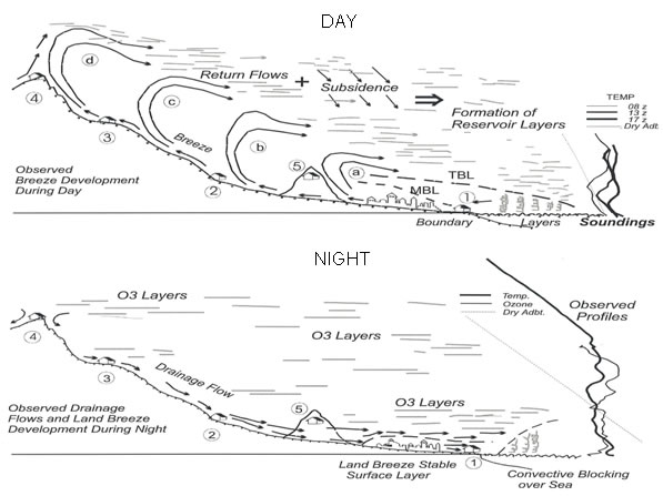
Figure 7. Top: Schematic of the atmospheric circulations in the coastal regions of the western Mediterranean on a summer day. Letters a-d indicate successive stages in the entrance of the seabreeze and the formation of stratified layers aloft. Bottom: The same for a summer night. Soundings at right, from the MECAPIP project instrumented flights (0541-0546 UTC 20 Jul 1989) extending to 3500 m altitude, illustrate the stratification over the sea some 40 km offshore (see also Figure 8 for the temperature profile obtained during the previous leg of the same flight). Common features in this and other soundings are: a quasi-isothermal, but strongly serrated, aspect in their lower » 2000 m, and a nearly adiabatic form in their upper parts. The latter suggests the sustained subsidence of a well-mixed airmass and also supports the notion that the upper layers are formed at the last stage of penetration of the combined breeze, i.e., over the mountain tops, after the air in the combined breeze has become well mixed during its travel over the heated surface, and within the last orographic chimney. At this point, the layer formation time is also the longest (4-6 hours). Finally, the total amount of sinking experienced by these quasi-adiabatic layers (as illustrated in Figure 8) is comparable to the altitude of the ridges over which the injection took place (e.g., 1000 m to 1500 m).


Figure 8. Top: Ozone (blue) and temperature (red) profiles measured over the Gulf of Valencia. These illustrate the layers formed in the return flows of the coastal circulations. Profiles A and B were obtained during the RECAPMA project (on July 16, 1991) over the points shown on the maps at right (blue triangles). The faint black temperature profile was obtained over the same area during the MECAPIP project (0527 to 0541 UTC on July 20, 1989). These illustrate how repetitive the coastal circulations can be over the Western Mediterranean Basin. Bottom: Out of 30 spiral flights, this overlay includes the profiles with the highest and the lowest potential temperatures observed in the return flows during the EC’s RECAPMA project in July 1991. The values span the 312 K to 315 K range in the upper reaches of the flights, and the 24º C to 26º C range at the surface. They suggest that the marine airmasses that enter the coastline at temperatures of » 24° to 26° C gain from 13 K to 19 K by the time they become injected into the uppermost return flows aloft. The red-dashed 303 K adiabatic profile (30ºC to 2000m) is a reference.

Figure 9. Simulation of the temperature profiles for the places shown at right, at the times indicated. The line with small red circles shows the modelling results at the UTC times indicated (full hour). These are two cases where the modelling results clearly underestimate the temperature profiles measured by the instrumented aircraft.


Figure 10. RAMS simulation of the wind field over the Mediterranean at 16:00 UTC on 19 July 1991. At approximately the same time two spirals were flown up and down the red line over the red triangle marked south of Majorca (data in Figure 8, 315 K profile). Top graph: The winds at a height of 14.8 m emerge from the centre of the Western Basin and increase in speed while flowing anticyclonically (clockwise) towards convergence lines located over the main mountain ranges surrounding the basin (in orange). Bottom: The vertical component of the wind speed along the 39.5 North Parallel (dotted blue line in the upper graph) shows deep orographic-convective injections (black solid traces) over Eastern Spain and, following to the right, over Sardinia and the west-facing coasts of Italy, Greece and Turkey. That is, to replace the surface air moving towards the coasts, continuity requires sinking of the air aloft, i.e., compensatory subsidence (dotted lines) over the seas.

Figure 11. Top left. One of the experimental deployment areas used in nine EC projects in the Mediterranean. It marks the sounding sites for the other graphs (red arrows). Tethered balloons were used in a vertical profiling mode at the coast (PORT), at 20 km inland (SICHAR), and at 78 km inland (VALBONA). The hourly evolution of the mixed layer at these sites, and the number of soundings used for the statistics are shown in each graph. In each sounding, the height to the first observed temperature inversion was considered to be the boundary (mixed) layer depth. The graphs show the average height of the BL (in blue) and the ± one standard deviation for each series. Oscillations in the BL height had been previously observed in the 1978 Nanticoke Power Plant Experiment on the north shore of Lake Erie, Canada (Portelli et al. 1982). In Valbona, the soundings were performed at selected time periods (early morning, afternoon, evening), instead of the half-hour cadence used on the other sites; hence, the observed gaps in the series.

Figure 12. The summer shower/storm cycle on Western Mediterranean coasts. Upper. Conditions in the past provided enough additional moisture to the marine airmass (seabreeze) to trigger precipitation almost every day at the » 1000 m altitude. This kept a large amount of water recirculating within the coastal system, i.e., surface water and acquifers. Note that the water evaporated at the coasts precipitates in the interior and, thus, that the real water cycle includes the acquifer that feeds the coastal marshes; i.e., they are all part of the same “water body”. Lower. Conditions with increased heating and less evapo-transpiration along (a drier) surface. With an average heating of 16 K (see Figure 9), the marine airmass needs to accumulate a water vapour mixing ratio ³ 20 g/kg to bring the Convective Consensation Level below the 2000 m altitude, i.e., the approximate height of the coastal mountain ranges. Under current conditions the average water vapour mixing ratio at the coast is » 14 g/km, and the contribution by surface evaporation along the path of the breeze is of the order of 5-6 g/km, which may not be enough to produce condensation and trigger a storm.

Figure 13. This figure from the TAR (IPCC 2001) synthesises the (idealized) development of Climate Models. The second module includes Land surface interactions. In the 4AR (IPCC 2007, 8.6.3.1 Water Vapour and Lapse Rate), it is stated that “In the planetary boundary layer, humidity is controlled by strong coupling with the surface, and a broad-scale quasi-unchanged RH response is uncontroversial”. The uncontroversial part of this statement could be false for any region outside flat terrains in the mid latitudes. The reason for this being that: when the edges of the continents wrap around a large interior sea like the Mediterranean, or a large semi-enclosed sea like the Sea of Japan, Continental Edge effects blend together to create their own large meso-meteorological circulation, particularly in summer. These large meso-a scale circulations (to » 2000 km) can dominate the weather patterns in these regions for months, and include vertical recirculation cycles lasting several consecutive days. Under these conditions, marine airmasses cross the coastline and become injected aloft over the mountains surrounding the sea. This produces a systematic folding of surface boundary layers over the sea. The results are modified temperature profiles, i.e., the layers have gained potential temperature, as well as modified vertical water vapour distribution, since the layers now include the additional water evaporated over land. The accumulation mode has been observed to reach 4500(+) m) over the enclosed Mediterranean Sea, and a similar process could also occur over other semi-enclosed large basins (Sea of Japan, South China Sea) in the subtropical latitudes.

DAY DAY + NIGHT
Figure 14 Averages of the NASA MODIS-Terra measurements for July 2000 and 2005. The Day product derived from the morning pass at 10:30 UTC emphasises the areas where the satellite looks down the deep orographic-convection developing at the fronts of the combined up-slope and seabreezes, i.e., around the edges of the basin (Figures 6, 7, and 10). It also outlines the deep inland penetration of the seabreezes over the desert areas of Tunisia, Libya and Egypt. The Day+Night product emphasises the areas over which water vapour accumulation occurs at the end of the diurnal cycle. That is, the water vapour that did not precipitate over the coastal mountains in the afternoon returns with the flows aloft and fills the Western Mediterranean Basin (to 4500 + m) and the Adriatic and Black seas with water vapour (layers). This produces an “accumulation mode” in summer and, without requiring the high evaporation rates of more tropical latitudes, the mechanisms described in the text are able, in just a few days, to generate a very large, deep and polluted air mass that increases both in moisture content and in potential instability with each passing day. The vertical circulation accumulation cycle can last for several days (i.e., 4 on the average and periods of up to 7 or more) and recur several times per month (up to 12 to 24 days in July-August). As a result, the monthly averages shown here are comparable to the column values of water vapour accumulated after 4 days of vertical recirculations.
.
